Central Valley Bioregion
Broad rolling bottomlands laced with lazy oak-lined rivers characterize this most-altered of the state’s bioregions. Once vast tule marshes sent up thick clouds of waterfowl while immense herds of elk, pronghorn antelope and other grazers crowded the grasslands; today only remnants of that landscape remain.
Vegetation
The Central Valley bioregion is the state’s top agricultural region. Ecosystems range from oak woodlands and grasslands to riparian forests. Vernal pools and freshwater marshes provide habitat for rare plants such as Mason’s lilaeopsis, San Joaquin woollythreads and California hibiscus.
Climate
In the northern part of the bioregion, summer hot spells are relieved by the Delta breezes, which carry moist air from the San Francisco Bay eastward through the Delta and into the Sacramento area. Autumns are mild and end abruptly with the coming of the winter fog, usually in late November. The "tule" fog blankets the valley from late November until February, keeping temperatures chilled. Rainfall ordinarily is frequent in winter, but snowfall is unusual because temperatures do not dip low enough. The southern part of this bioregion is hot and dry in summer with long, sunny days. Winters are damp and the landscape is often blanketed in a heavy fog.
Major natural features and areas
The northern portion of this bioregion is flat for the most part, though the Sacramento-San Joaquin River Delta has some hills, along with its freshwater marshes. The region is bordered by the coastal range foothills to the west, the snow-capped peaks of the Sierra Nevada to the east and the Tehachapi Range to the south. Two major rivers– the Sacramento and the American– carry water that originates in the Sierra Nevada south and west into the Delta. The Central Valley bioregion is the focus of much debate because of the conflicting demands on its water resources. Other rivers in the northern part of the bioregion include the Cosumnes, lower Feather, Bear, and Yuba rivers. The region is home to the state capital, Sacramento.
The southern portion of this bioregion is a broad, flat valley. Habitat includes vernal pools, valley sink scrub and saltbush, freshwater marsh, grasslands, arid plains, orchards, and oak savannah. The growth of agriculture means that much of what was once native grassland, woodland, and wetland is now farmland. The major river is the San Joaquin; tributaries of the lower Stanislaus, Tuolumne, Merced, and Fresno rivers also flow through the area.
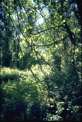
Riparian forest. Photo courtesy of Marc Hoshovsky, California Dept. of Fish and Game.
The California Aqueduct runs through this part of the bioregion, as do the Kings, Kaweah, and Kern rivers. About one-fifth of the state’s remaining cottonwood and willow riparian forests are found along the Kern River in the South Fork Wildlife Area.
Wildlife
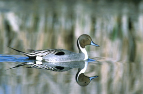
The seasonal marshes in the northern part of this bioregion are a major wintering site for waterfowl. Species include northern pintails, snow geese, tundra swans, mallards, grebes, herons, egrets, and hawks. Wildlife such as black-tailed deer, coyotes, river otters, muskrats, beavers, osprey, salmon, and swallowtail butterflies all reside in the northern part of this bioregion. In the southern part of the bioregion millions of acres of wetlands once flourished but stream diversions for irrigation dried up about 95 percent. Seasonal wetlands are still found at the Kern National Wildlife Refuge west of Delano, drawing a variety of ducks, shorebirds and song birds as well as endangered peregrine falcons. Great blue herons, beavers, coyotes, black bears, mountain lions, red-shouldered hawks and mule deer are found near the Kern River in the South Fork Wildlife Area. The San Luis Dam and Reservoir area attracts wintering bald eagles, abundant ducks, gopher snakes and black-tailed deer. Threats
Water– Water conservation is a critical issue in this region, which is one of the fastest-growing in the state. Increasing development means less water for the area’s huge agricultural industry and reduces water levels in the region’s rivers, threatening fish populations.
Disappearing farmland and habitat– Rampant development around towns such as Sacramento each year covers up vast tracts of some of the world’s richest farmland. Development and industrial agriculture also are fast wiping out the dwindling riparian oak forests, which harbor rare valley, blue and Engelmann oaks.
For more information on threats to the Central Valley Bioregion, visit:
Save the American River Association
P.O. Box 277638
Sacramento, CA 95827-7638
Phone (916) 387-1763
cripplecreek1@juno.com
Environmental Council of Sacramento
909 12th St., Suite 118 B
Sacramento, CA 95814
Phone (916) 444-6666
Ewithycombe@sierraresearch.com
American River Conservancy
www.arconservancy.org
Friends of the River
www.friendsoftheriver.org
Water Education Foundation
www.watereducation.org
©2025 Forests Forever. All Rights Reserved.